How do I...?


![]()
Community History |
Frequently Asked Questions |
Local History Materials |
Image Gallery
Community Links |
Library History |
Community Profile
 Gardena, once the berry-growing
capital of southern California, is today called the "Freeway City" because it
is bordered by the Artesia, Harbor, and San Diego freeways to its south, east,
and west, respectively. Its modern-day urban designation is a far cry from
Gardena's early reputation as a "garden spot," a lush oasis of greenery fed
by the waters of the Dominguez Slough. Long before it was officially
incorporated in 1930 by combining the rural communities of Moneta and
Strawberry Park, Gardena was known first by Gabrielino Indians and later
Spanish and American settlers as a long green stretch of land amidst coastal
sage scrub.
Gardena, once the berry-growing
capital of southern California, is today called the "Freeway City" because it
is bordered by the Artesia, Harbor, and San Diego freeways to its south, east,
and west, respectively. Its modern-day urban designation is a far cry from
Gardena's early reputation as a "garden spot," a lush oasis of greenery fed
by the waters of the Dominguez Slough. Long before it was officially
incorporated in 1930 by combining the rural communities of Moneta and
Strawberry Park, Gardena was known first by Gabrielino Indians and later
Spanish and American settlers as a long green stretch of land amidst coastal
sage scrub.
 The community originally evolved from part of the roughly 43,000-acre Spanish
land grant, the Rancho San Pedro, given to Juan Jose Dominguez around 1800.
The site was later named the Rosecrans Rancho after Union Army Major General
William Starke Rosecrans, who bought 16,000 acres following the Civil War.
This land would later be bordered on the north by Florence Avenue, on the
south by Redondo Beach Boulevard, on the east by Central Avenue, and on the
west by Arlington Avenue. After the property changed hands several times,
early Gardena was laid out with Figueroa and 161st streets at its center, the
idea being that the Los Angeles and Redondo Railway would pass next to it when
extended south between those two communities. When the route instead came in
along Vermont Avenue, the community moved to accommodate the change.
The community originally evolved from part of the roughly 43,000-acre Spanish
land grant, the Rancho San Pedro, given to Juan Jose Dominguez around 1800.
The site was later named the Rosecrans Rancho after Union Army Major General
William Starke Rosecrans, who bought 16,000 acres following the Civil War.
This land would later be bordered on the north by Florence Avenue, on the
south by Redondo Beach Boulevard, on the east by Central Avenue, and on the
west by Arlington Avenue. After the property changed hands several times,
early Gardena was laid out with Figueroa and 161st streets at its center, the
idea being that the Los Angeles and Redondo Railway would pass next to it when
extended south between those two communities. When the route instead came in
along Vermont Avenue, the community moved to accommodate the change.
 Farming became Gardena's main industry early in the twentieth century, though
berries, especially strawberries, were its claim to fame. The community
became known as "Berryland," and was renowned for its Strawberry Day Festival
and parade every May. The berry industry dwindled with World War I, when land
was used first for other crops and then later for development.
Farming became Gardena's main industry early in the twentieth century, though
berries, especially strawberries, were its claim to fame. The community
became known as "Berryland," and was renowned for its Strawberry Day Festival
and parade every May. The berry industry dwindled with World War I, when land
was used first for other crops and then later for development.
Website Links:
Print Sources:
- Leonard, Olive Hensel and Emily D. Cost. A Short History of Gardena Valley. June 1934. [Available at the Gardena Mayme Dear Library]
Images:
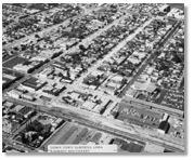
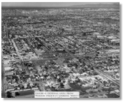
- Aerial view of downtown Gardena, looking southwest, 1968
[Courtesy of the Gardena City Clerk's Office] - Gardena from Harbor Freeway, looking west, 1968
[Courtesy of the Gardena City Clerk's Office] - Gardena City Hall, c. 1964
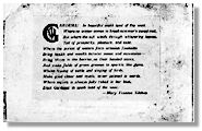
[Courtesy of the Gardena City Clerk's Office] - Poem about Gardena printed in a pamphlet advertising the advantages of the area, c. 1900
[County of Los Angeles Public Library] - Gardena city seal bearing the city logo 'Freeway City.'
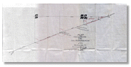
[Courtesy of the Gardena City Clerk's Office] - Hand-drawn linen plat map showing the location of the San Pedro Ranch line, 1893
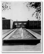
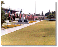
[Courtesy of the Gardena City Clerk's Office] - Gardena Civic Center with flags, 1980
[Courtesy of the Gardena City Clerk's Office]
![]()
Agoura Hills |
Antelope Valley |
Carson |
Catalina Island |
Claremont |
East Los Angeles
Gardena |
Lakewood |
La Puente Valley |
Pico Rivera |
San Dimas |
San Fernando
San Gabriel |
South Gate |
Willowbrook
Home | Search Our Site | FAQ | Contact Us | Credits | Accessibility | Privacy
Copyright © County of Los Angeles Public Library