How do I...?


![]()
Community History |
Frequently Asked Questions |
Local History Materials |
Image Gallery
Community Links |
Library History |
Community Profile
 Pico
Rivera is a fast-growing city of about 65,200 people in a more than
eight-square-mile area located on the eastern border of the Los Angeles
basin and southern border of the San Gabriel valley. Called Sejat
by Native Americans who believed that the world began in the area where
the city is now, Pico Rivera today has changed from its original
forested and bucolic state into an urban region easily accessible by
car (via the Pomona, Santa Ana, and San Gabriel freeways),
plane (via Los Angeles International Airport), and train (via the Union
Pacific Railroad, Southern Pacific Line, and the Atchison, Topeka and
Santa Fe Railway Company).
Pico
Rivera is a fast-growing city of about 65,200 people in a more than
eight-square-mile area located on the eastern border of the Los Angeles
basin and southern border of the San Gabriel valley. Called Sejat
by Native Americans who believed that the world began in the area where
the city is now, Pico Rivera today has changed from its original
forested and bucolic state into an urban region easily accessible by
car (via the Pomona, Santa Ana, and San Gabriel freeways),
plane (via Los Angeles International Airport), and train (via the Union
Pacific Railroad, Southern Pacific Line, and the Atchison, Topeka and
Santa Fe Railway Company).
 The towns of Pico and Rivera, from which the city originated,
officially began in the 1880s when the Union Pacific and
Atchison, Topeka and Santa Fe railroads built rail lines through the
region. Blessed with fertile soil, both communities became known for
their walnuts, avocados, and other crops, and retained their
agricultural character through the mid-1940s. When a growing influx of
new residents came to Pico Rivera after the end of World War II,
development began supplanting farming as the landscape became dotted
with housing subdivisions, schools, stores, and churches.
The towns of Pico and Rivera, from which the city originated,
officially began in the 1880s when the Union Pacific and
Atchison, Topeka and Santa Fe railroads built rail lines through the
region. Blessed with fertile soil, both communities became known for
their walnuts, avocados, and other crops, and retained their
agricultural character through the mid-1940s. When a growing influx of
new residents came to Pico Rivera after the end of World War II,
development began supplanting farming as the landscape became dotted
with housing subdivisions, schools, stores, and churches.
As the population grew, so did residents' collective sense of civic duty and desire to blend the two separate towns. On January 7, 1958, the majority of voters in Pico and Rivera voted to incorporate as one municipality and with the decision becoming official that January 29, Pico Rivera became Los Angeles County's 61st city. More information about Pico Rivera can be found in the following sources:
|
Website Links:Print Sources:
|
Places to Visit:
- Pico Rivera Historical Museum
9122 Washington Boulevard
Pico Rivera, CA 90660
(562) 949-7100
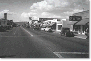
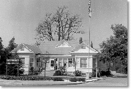
Images:
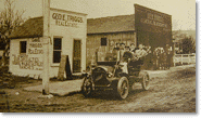
- Pico Rivera street scene, 1907
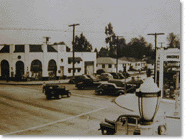
[Courtesy of the Pico Rivera History and Heritage Society Museum] - Whittier Boulevard and Durfee in Pico Rivera, 1930s
[Courtesy of the Pico Rivera History and Heritage Society Museum] - Pico Rivera street scene, 1940s
[Courtesy of the Pico Rivera History and Heritage Society Museum] - First Pico Rivera City Hall, c. 1958
[Courtesy of the Pico Rivera History and Heritage Society Museum]
![]()
Agoura Hills |
Antelope Valley |
Carson |
Catalina Island |
Claremont |
East Los Angeles
Gardena |
Lakewood |
La Puente Valley |
Pico Rivera |
San Dimas |
San Fernando
San Gabriel |
South Gate |
Willowbrook
Home | Search Our Site | FAQ | Contact Us | Credits | Accessibility | Privacy
Copyright © County of Los Angeles Public Library