
How do I...?


![]()
Community History |
Frequently Asked Questions |
Local History Materials |
Image Gallery
Community Links |
Library History |
Community Profile
 San
Dimas, a city of about 35,000 people, is located approximately thirty
miles east of downtown Los Angeles, in the foothills of the San Gabriel
Mountains and straddling the San Gabriel and Pomona valleys. The
community started out in the early 1800s being called Mud Springs,
named for the adjacent Mud Springs marsh whose wet and swampy terrain
characterized the region. Though Gabrielino Indians occupied the area
as early as 1000 B.C. and other tribes as much as 7,000 years ago, it
was not until 1774 that white men first ventured into the region, when
Spanish frontier soldier Juan Baptista DeAnza and his party, en
route from Mexico to Monterey, passed through the area that
later became Mud Springs.
San
Dimas, a city of about 35,000 people, is located approximately thirty
miles east of downtown Los Angeles, in the foothills of the San Gabriel
Mountains and straddling the San Gabriel and Pomona valleys. The
community started out in the early 1800s being called Mud Springs,
named for the adjacent Mud Springs marsh whose wet and swampy terrain
characterized the region. Though Gabrielino Indians occupied the area
as early as 1000 B.C. and other tribes as much as 7,000 years ago, it
was not until 1774 that white men first ventured into the region, when
Spanish frontier soldier Juan Baptista DeAnza and his party, en
route from Mexico to Monterey, passed through the area that
later became Mud Springs.
 Other explorers, early settlers and cattle ranchers trickled into the
region in the century that followed, but the community was formally put
on the map in 1887, the year the Santa Fe Railroad was completed and
began operating a rail line through the area. The railroad's
arrival triggered a land boom. The newly formed San Jose Ranch Company
laid out streets and lots, land agent E.M. Marshall opened the first
business, a hardware store, at the corner of Bonita and
Depot streets and the name Mud Springs was changed to San Dimas.
Other explorers, early settlers and cattle ranchers trickled into the
region in the century that followed, but the community was formally put
on the map in 1887, the year the Santa Fe Railroad was completed and
began operating a rail line through the area. The railroad's
arrival triggered a land boom. The newly formed San Jose Ranch Company
laid out streets and lots, land agent E.M. Marshall opened the first
business, a hardware store, at the corner of Bonita and
Depot streets and the name Mud Springs was changed to San Dimas.
San Dimas evolved into an agricultural community, especially noted for its orange and other citrus crops which were shipped all over the world The citrus nurseries faded and finally disappeared in the mid-1900s with increasing development in San Dimas. After adjacent communities started annexing pieces of San Dimas in the late 1950s, it incorporated as a city in 1960. Today, conscious of its heritage, San Dimas maintains an early western look in its downtown area, complete with wooden sidewalks and old-fashioned western storefront facades. More information about San Dimas can be found in the following sources:
Website Links:
Print Sources:
- Glauthier, Martha. The History of San Dimas, California. San Dimas, CA: The San Dimas Historical Society, 1997.
- Pictorial memories of Southern California's Inland Valley. Inland Valley Daily Bulletin. Marceline: Heritage House Publishing, 1995.
- Hoover, J. Howard. Profile of San Dimas. San Dimas: The San Dimas Press, 1961.
- Polos, Nicholas C. San Dimas: Preserving the Western Spirit. San Dimas, CA, 1990.
Places to Visit:
- The San Dimas Historical Society
210 W. Bonita Avenue
San Dimas, CA 91773
(909) 592-1190
Images:
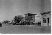
- North side of Bonita Avenue, looking west from San Dimas Avenue, 1920
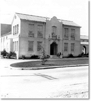
[Courtesy of the San Dimas Historical Society] - Bonita High School (now Damien High School) in San Dimas, 1928
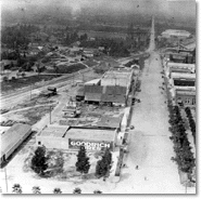
[Courtesy of the San Dimas Historical Society] - Aerial view showing San Dimas from San Dimas Avenue, looking west on Bonita Avenue, 1920
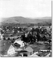
[Courtesy of the San Dimas Historical Society] - The view from Second Street and Monte Vista, looking south toward downtown San Dimas from Way Hill,
1920s
[Courtesy of the San Dimas Historical Society]
![]()
Agoura Hills |
Antelope Valley |
Carson |
Catalina Island |
Claremont |
East Los Angeles
Gardena |
Lakewood |
La Puente Valley |
Pico Rivera |
San Dimas |
San Fernando
San Gabriel |
South Gate |
Willowbrook
Home | Search Our Site | FAQ | Contact Us | Credits | Accessibility | Privacy
Copyright © County of Los Angeles Public Library